Where Is Nepal Located? Is Nepal Part of India or China?
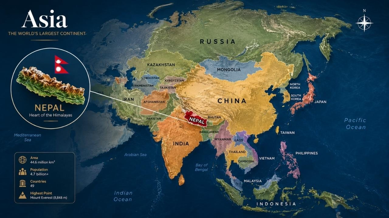
Nepal is a landlocked country in South Asia, located in the Himalayan region between India and China. Although Nepal shares international borders with both countries, it is not part of India or China. Nepal is an independent nation with its own government, territory, laws, currency, and national identity.
Geographically, China borders Nepal to the north, while India borders Nepal along the south, east, and west. According to the United Nations, Nepal covers approximately 147,181 square kilometers, making it a relatively small country by area but one of the world's most geographically diverse destinations. Kathmandu, the capital and largest urban centre, lies in the Kathmandu Valley in the central part of the country and serves as Nepal's principal political, cultural, and international gateway.
Nepal's location is particularly significant because the country stretches from the low-lying Terai plains in the south to the high Himalayan mountains in the north. This dramatic elevation range creates diverse landscapes, climates, ecosystems, and communities within a relatively short north–south distance.
The country is home to Mount Everest, the world's highest mountain above sea level, along with seven other peaks exceeding 8,000 metres. Nepal's northern landscape forms part of the greater Himalayan mountain system, while its southern plains connect geographically and economically with the Indian subcontinent.
Nepal's position between two of Asia's largest countries also makes it an important geographical link between South Asia and the Himalayan region. The country shares approximately 1,770 kilometres of international boundary with India and approximately 1,414 kilometres with China, although border-length figures can vary slightly by source and measurement method. Nepal joined the United Nations on December 14, 1955, and maintains diplomatic relations with countries around the world.
For travellers, Nepal's location makes it a gateway to some of the world's most famous Himalayan destinations, including Everest Base Camp, Annapurna Base Camp, Pokhara, Langtang, Mustang, and Kathmandu Valley. Understanding where Nepal is located and recognising that it is an independent country between India and China provides the essential geographical context for exploring its mountains, culture, history, and tourism destinations.
Where Is Nepal Located on the World Map?
Nepal sits in South Asia, situated in the heart of the Himalayan region, tucked in between India and China. On a world map, Nepal appears as a narrow, east–west orientated country north of India and south of China's Tibet Autonomous Region. Even though it's fairly small in size, Nepal packs in an amazing range of landscapes, from the flat, low-lying Terai plains all the way up to towering Himalayan peaks. Its location places it between two of Asia's largest countries while giving it a distinct national territory and international identity. Nepal is a landlocked, independent, and sovereign country, and it shares land borders only with India and China. Nepal is home to some of the world's most iconic mountain landscapes, including Mount Everest and several other peaks that soar above 8,000 metres.

Nepal's Geographic Coordinates
Nepal lies between 26°22′N and 30°27′N latitude and 80°04′E and 88°12′E longitude, placing it entirely within the Northern and Eastern Hemispheres. The country stretches about 800 kilometres from east to west but is much narrower from north to south, usually between 150 and 250 kilometres wide. Because of this long, narrow shape, Nepal shows great variation in elevation, climate, vegetation, and landscape from one region to another.
Which Countries Border Nepal?
Nepal shares its borders with only two countries, China and India. China lies to the north, mainly through the Tibet Autonomous Region, while India surrounds Nepal on the south, east, and west sides.
Direction | Bordering Country |
North | China |
East | India |
South | India |
West | India |
Because of this location between two large countries, people sometimes wonder whether Nepal is a part of India or China. However, Nepal does not belong to either of them; it is an independent, sovereign nation situated between the two.
How Big Is Nepal?
According to United Nations data, Nepal covers about 147,181 square kilometres (56,827 square miles). It stretches roughly 800 kilometres from east to west, while its north–south width ranges from about 150 to 250 kilometres. Despite its small size, Nepal holds an amazing range of elevations, from the low plains of the Terai to Mount Everest, standing at 8,848.86 metres, the highest point on Earth.
Nepal is much smaller than its two neighbours. India spans over 3.2 million square kilometres, and China covers about 9.6 million square kilometres. Yet Nepal's small size doesn't limit its geographic variety; within this compact land, it holds plains, hills, valleys, alpine regions, glaciers, and some of the tallest mountains in the world.
Is Nepal Part of India or China?
No. Nepal is not part of India or China. Nepal is an independent and sovereign country in South Asia, located between India and China. It has its own government, constitution, national territory, currency, and legal system. Nepal also conducts its own foreign affairs and maintains diplomatic relations with countries around the world. India and China are Nepal's neighbouring countries, not countries that Nepal belongs to. China borders Nepal to the north, while India shares borders with Nepal along the south, east, and west. Nepal's independent status is also reflected in its membership in international organisations, including the United Nations, which Nepal joined in 1955.
Why Do People Think Nepal Is Part of India or China?
Nepal is sometimes confused with India or China because of its geographic position, close cultural and economic connections, and relatively small size. Nepal shares an open border and extensive cultural and economic ties with India, while its northern border connects it with China's Tibet Autonomous Region. Its location between two much larger countries can also make it easy to overlook on a world map. However, geographic proximity and close international relationships do not change Nepal's status as an independent and sovereign country.
Nepal's Borders With India and China
Nepal shares international land borders with only two countries: India and China. India borders Nepal along the south, east, and west, while China borders Nepal to the north through the Tibet Autonomous Region. These borders are important for Nepal's trade, tourism, transportation, cultural connections, and regional relations. Together, they define Nepal's unique geographical position between the Indian plains and the Tibetan Plateau.
Nepal–India Border
The Nepal-India border extends for about 1,770 km and connects Nepal with five Indian states: Uttarakhand, Uttar Pradesh, Bihar, West Bengal, and Sikkim. The Nepal-India border has facilitated trade, tourism, employment, and cultural exchange between the two countries because of bilateral agreements and close cross-border ties.
Some important Nepal–India border points include:
Birgunj–Raxaul: One of the most important trade routes between Nepal and India.
Bhairahawa–Sunauli: A major entry point for travellers heading toward Lumbini and other destinations in Nepal.
Kakarbhitta–Panitanki: An important eastern border crossing connecting Nepal with West Bengal and onward routes.
Nepalgunj–Rupaidiha: A significant crossing for trade and travellers in western Nepal.
Dhangadhi–Gauriphanta: An important border point in far-western Nepal.
The Nepal–India border plays a major role in Nepal's international trade and overland tourism, as India is Nepal's largest neighbouring market and a major transit route for goods entering the country.
Nepal–China Border
The Nepal–China border extends for approximately 1,414 kilometres along Nepal's northern side. It separates Nepal from China's Tibet Autonomous Region and runs through some of the most rugged and mountainous terrain in the Himalayas. Unlike the relatively accessible southern border, the northern frontier includes high mountain passes, glaciers, and remote valleys.
Important Nepal–China border areas and crossings include the following:
Rasuwagadhi–Kerung: An important trade and overland route between Nepal and Tibet.
Tatopani–Zhangmu: A historic trade route connecting central Nepal with Tibet.
Korala: A northern Mustang border point associated with trade and regional connectivity.
Hilsa–Purang: An important route in the Humla region, particularly for travel toward western Tibet.
The Nepal–China border is strategically and economically important because it provides Nepal with access to the Tibetan Plateau and China, while several Himalayan routes support cross-border trade and regional connectivity.
Nepal's Two International Borders at a Glance
Feature | Nepal–India Border | Nepal–China Border |
Approx. length | 1,770 km | 1,414 km |
Direction from Nepal | South, east & west | North |
Neighboring | Indian states | Tibet Autonomous Region |
Terrain | Plains and foothills | High Himalayan mountains |
Major routes | Birgunj, Sunauli, Kakarbhitta, Nepalgunj | Rasuwagadhi, Tatopani, Korala, Hilsa |
Main importance | Trade, tourism, transport & cultural exchange | Trade, tourism & northern connectivity |
Nepal Geography: From the Terai Plains to the Himalayas
Nepal has remarkable geographic and cultural diversity within a relatively small area. The country stretches from the warm Terai Plains in the south, through the green Hill Region, to the high Himalayan region in the north. Each region has its own landscape, climate, communities, traditions, languages, religious practices, and way of life. Hinduism and Buddhism are widely practised throughout Nepal, while Islam, Christianity, Kirat traditions, and other local beliefs also contribute to the country's religious diversity. Different ethnic and cultural communities have preserved their own festivals, food, clothing, music, architecture, and customs, making Nepal both geographically and culturally diverse.

Terai Plains
The Terai Plains are a land of fertile valleys and a warm climate that lies along the border with India. The region is home to an incredible diversity of communities, including Tharu, Madhesi, Brahmin people, Chhetri, and Muslims. There is a mix of Hindu, Buddhist, Islamic, and Christian traditions. The culture of the region is multifaceted; it is famous for its Tharu traditional dancing, dresses, food, and festivals that are part of the local heritage. Notable for its cultural and religious significance is the region of Lumbini, the birthplace of Gautama Buddha. Another popular pilgrimage is Janakpur. Agriculture, trade, religion, and festivals play a significant role in the life of the locals, as well as cultural and traditional customs and lifestyles.
Hill Region
The Hill Region is located between the Terai Plains and the high mountains of the Himalayan belt. It is a region of green hills, valleys, forests, rivers, and traditional villages. The region is inhabited by people belonging to different ethnic groups such as Newar, Tamang, Gurung, Magar, Rai, Limbu, Brahmin, and Chhetri. Similarly, Hinduism and Buddhism are widely practised along with indigenous religions. The people of the region celebrate a variety of festivals like Dashain, Tihar, Losar, Buddha Jayanti, and Indra Jatra according to their religious affiliations and local festivals. Newar people are well known for their traditional architecture, artifacts, food, and celebration of the Tihar festival in the Kathmandu Valley. In addition, Kathmandu and Pokhara are the cultural, commercial, and tourist hubs of the Hill region.
Himalayan Region
The Himalayan region is considered to be the area located in the north of Nepal, characterised by high mountains, glaciers, valleys, and isolated communities. The culture and traditions of the local people have been formed due to adaptation to the mountainous climate. There are several ethnic groups in the Himalayas, including the Sherpa, Tamang, Thakali, and other Himalayan peoples. Buddhism is widespread in many of these communities; monasteries, stupas, prayer flags, and prayer wheels are typical elements of the Himalayan cultural landscape. Hinduism and ancient beliefs are also part of the traditions of the local people. Sherpa people are famous because of their close connection with mountaineering. The most popular places to visit in the Himalayas are Everest, Namche Bazaar, Mustang, Manang, and Langtang, where people can see traditional ways of life, religion, and mountainous scenery.
Where Is Mount Everest Located?
Mount Everest stands right on the border between Nepal and China, deep in the Himalayas. At 8,848.86 metres (29,031.69 feet), it's the highest point on Earth. The Nepali people know it as Sagarmatha, and in Tibet, it is known by the name Chomolungma. On the Nepal side, Mount Everest lies in Solukhumbu District within Sagarmatha National Park. Most people fly into Lukla and then start trekking from there. Along the way, you'll pass through some famous villages: Namche Bazaar, Tengboche, Dingboche, and finally Gorak Shep before reaching Everest Base Camp. One thing is important to note: while the actual summit sits exactly on the Nepal-China border, the popular southern Everest Base Camp is located in Nepal.
Is Mount Everest in Nepal or China?
Mount Everest is located on the border between Nepal and China. The summit lies on the international boundary, while the famous southern Everest Base Camp is located in Nepal, and the northern climbing route is accessed from China's Tibet Autonomous Region. So, Everest is best described as a Nepal–China border mountain, rather than a mountain located entirely within one country.
Key Facts About Mount Everest
Location: Himalayas, on the Nepal–China border
Elevation: 8,848.86 meters (29,031.69 feet)
Nepali name: Sagarmatha
Tibetan name: Chomolungma
Nepal side: Solukhumbu District, Sagarmatha National Park
Nepal's Everest region: Khumbu
Southern Everest Base Camp: Located in Nepal
Northern Everest Base Camp: Located in Tibet, China
Southern climbing route: Accessed from Nepal
Northern climbing route: Accessed from Tibet, China
Global significance: The world's highest mountain above sea level
In short: Mount Everest sits on the Nepal–China border, but Everest Base Camp on the popular southern route is in Nepal.
Nepal Location Compared With India and China
Nepal is much smaller in area than both India and China, but it occupies an important location between them in the Himalayan region. Nepal covers about 147,181 square kilometres, compared with more than 3.2 million square kilometres for India and about 9.6 million square kilometres for China. Nepal is landlocked, while India and China both have coastlines. Nepal shares its international land borders only with India and China. India surrounds Nepal along three sides, while China borders Nepal along its northern side.
Feature | Nepal | India | China |
Region | South Asia | South Asia | Asia |
Capital | Kathmandu | New Delhi | Beijing |
Approx. area | 147,181 km² | ~3.29 million km² | ~9.6 million km² |
Landlocked | Yes | No | No |
Borders Nepal | —- | Yes | Yes |
Nepal at a Glance: Location and Geographic Facts
Nepal is a landlocked country in South Asia and part of the Himalayan region. Its capital is Kathmandu, and its total area is approximately 147,181 square kilometres. The country shares borders with India and China, with China to the north and India to the south, east, and west. Nepal's highest point is Mount Everest at 8,848.86 metres, while its southern Terai region contains some of its lowest elevations. The country is known for its mountains, valleys, forests, rivers, glaciers, cultural heritage, and diverse ecosystems.
Geographic Fact | Nepal |
Continent | Asia |
Region | South Asia |
Capital | Kathmandu |
Area | 147,181 km² |
Highest point | Mount Everest – 8,848.86 m |
Country type | Landlocked |
Northern neighbor | China |
Southern, eastern & western neighbors | India |
Official language | Nepali |
Currency | Nepalese rupee |
Why Is Nepal Famous?
Nepal is famous for its Himalayan mountains, Mount Everest, unique culture, ancient heritage, and adventure tourism. Despite its small size, the country offers a remarkable mix of high mountains, traditional villages, wildlife, religious sites, and diverse landscapes. Its natural and cultural attractions make Nepal a well-known destination for travellers from around the world.
Mount Everest: Home to Mount Everest, the world's highest mountain at 8,848.86 metres.
The Himalayas: Nepal contains some of the world's highest peaks and dramatic Himalayan landscapes.
Eight 8,000-Metre Peaks: Nepal is home to eight of the world's fourteen mountains above 8,000 metres.
Trekking: Famous routes include the Everest Base Camp Trek, Annapurna Circuit, and Langtang Valley Trek
Rich Culture: Nepal has diverse ethnic communities, languages, traditions, festivals, temples, and monasteries.
Kathmandu Valley: Known for historic temples, monuments, palaces, and UNESCO World Heritage sites.
Lumbini: Traditionally recognised as the birthplace of Gautama Buddha and an important Buddhist pilgrimage destination.
Wildlife: National parks such as Chitwan National Park offer opportunities to see rhinos, crocodiles, elephants, and other wildlife.
Adventure Activities: Nepal is popular for mountaineering, trekking, rafting, paragliding, bungee jumping, and mountain flights.
Unique Landscapes: The country stretches from the Terai plains to the high Himalayas, creating remarkable geographic and climatic diversity.

Where Is Kathmandu Located?
Kathmandu is the capital and largest city of Nepal, located in the Kathmandu Valley in central Nepal. The city sits at approximately 1,400 metres above sea level and is surrounded by hills. Kathmandu is Nepal's main political, economic, cultural, and tourism centre and serves as the country's primary international gateway. Most international travellers arriving by air enter Nepal through Tribhuvan International Airport. The wider Kathmandu Valley includes Kathmandu, Lalitpur, and Bhaktapur and is home to numerous historic temples, monuments, and cultural attractions. Travellers heading toward Everest, Annapurna, Langtang, Mustang, and other trekking regions often begin their journey in Kathmandu.
What Are the Best Places to Visit in Nepal?
Nepal offers destinations for travellers interested in mountains, trekking, culture, wildlife, history, and adventure. Kathmandu is best known for its historic temples and cultural sites, while Pokhara is famous for Phewa Lake, mountain views, and outdoor activities. The Everest region attracts visitors who want to experience the world's highest mountain, while the Annapurna region offers some of Nepal's most popular trekking routes. Chitwan is known for wildlife and jungle safaris, and Lumbini is an important Buddhist pilgrimage destination. Mustang offers dramatic high-altitude landscapes and Tibetan-influenced culture, while Langtang is known for its mountain valleys and trekking trails.
Destination | Best Known For |
Kathmandu | Culture, temples and heritage |
Pokhara | Lakes, mountains and adventure |
Everest Region | Mount Everest and trekking |
Annapurna Region | Himalayan trekking and villages |
Chitwan | Wildlife and jungle safaris |
Lumbini | Buddhist heritage |
Mustang | High-altitude landscapes |
Langtang | Mountains and trekking |

Is Nepal Safe to Visit?
Nepal is a popular destination for international travellers, but visitors should prepare according to their destination and type of trip. Travelling in Kathmandu, Pokhara, and other lower-altitude areas requires normal travel precautions, while high-altitude trekking requires additional preparation. Travellers should check weather conditions, follow local regulations, allow enough time for acclimatisation, and carry appropriate clothing and equipment when visiting mountain areas. Travel insurance is especially important for trekking and adventure activities. Because weather, road conditions, trekking routes, and local regulations can change, visitors should check current official travel information before travelling.
Conclusion
Nepal is an independent, landlocked country in South Asia, located in the Himalayan region between India and China. China borders Nepal to the north, while India borders it to the south, east, and west. Nepal covers approximately 147,181 square kilometres and has a remarkable range of landscapes, from the Terai plains and middle hills to the high Himalayas.
Nepal is not part of India or China. It has its own government, constitution, territory, currency, and international identity. The country's unique location makes it home to Mount Everest, eight mountains above 8,000 metres, diverse landscapes, historic cities, wildlife areas, and world-famous trekking routes.
In short, Nepal is a sovereign South Asian country located between India and China, best known for the Himalayas, Mount Everest, rich culture, and extraordinary natural diversity.
Frequently Asked Questions About Nepal's Location
1. What Is the Simplest Way to Understand Nepal's Location?
The simplest way to remember Nepal's location is that Nepal is an independent country in South Asia, located between India and China, with India to the south, east, and west and China to the north.
2. Is Nepal a Separate Country From India?
Yes. Nepal is a separate and independent country from India. Nepal has its own government, constitution, territory, currency, and international relations. India is Nepal's neighbouring country, not the country Nepal belongs to.
3. Is Nepal a Separate Country From China?
Yes. Nepal is also a separate country from China. China shares Nepal's northern border through the Tibet Autonomous Region, but Nepal is an independent sovereign state.
4. Where Exactly Is Nepal Located?
Nepal is located in South Asia, in the Himalayan region between India and China. Its northern border meets China, while India borders Nepal along its southern, eastern, and western sides.
5. Which Side of Nepal Borders China?
China borders Nepal along its northern side. The border mainly connects Nepal with China's Tibet Autonomous Region and passes through some of the highest and most mountainous areas of the Himalayas.
6. Which Side of Nepal Borders India?
India borders Nepal along the southern, eastern, and western sides. Nepal shares its longest international land boundary with India.
7. How Many Countries Border Nepal?
Nepal has two international land-bordering countries: India and China. India borders Nepal on three sides, while China borders it along the north.
8. Does Nepal Share a Border With Tibet?
Nepal shares a border with China's Tibet Autonomous Region. Tibet lies immediately north of Nepal across the Himalayan mountain range.
9. Is Nepal Between India and China?
Yes. Nepal is geographically located between India and China. India lies mainly to Nepal's south, east, and west, while China's Tibet Autonomous Region lies to the north.
10. Does Nepal Have a Coastline?
No. Nepal is a landlocked country, so it does not have a coastline or direct access to the sea. India and China surround Nepal geographically, but neither country contains Nepal.
11. Is Nepal in South Asia or East Asia?
Nepal is classified as a South Asian country. It is located in the Himalayan region between South Asia's Indian plains and China's Tibetan Plateau.
12. Where Is Nepal Located Relative to India?
Nepal is located north of India. The two countries share a long international border, and India borders Nepal along its southern, eastern, and western sides.
13. Where Is Nepal Located Relative to China?
Nepal is located south of China's Tibet Autonomous Region. The Himalayas form much of the natural boundary between Nepal and China.
14. Is Kathmandu in India or Nepal?
Kathmandu is in Nepal. It is the capital and largest city of Nepal and is located in the Kathmandu Valley in the central part of the country.
15. Is Mount Everest in Nepal or China?
Mount Everest is located on the Nepal–China border. The southern side of the mountain and the popular Everest Base Camp trekking route are in Nepal, while the northern route is accessed from Tibet.
16. Is Everest Base Camp in Nepal or China?
The famous southern Everest Base Camp is in Nepal, in the Khumbu region of Solukhumbu District. It is the starting point for many expeditions attempting to climb Everest from the Nepal side.
17. Does Nepal Share a Border With Bhutan?
No. Nepal does not directly border Bhutan. India lies between Nepal and Bhutan, so the two countries are geographically close but do not share a land border.
18. Does Nepal Share a Border With Bangladesh?
No. Nepal does not share a direct land border with Bangladesh. India lies between Nepal and Bangladesh, although the countries are relatively close within South Asia.
19. Is Nepal a Himalayan country?
Yes. Nepal is a Himalayan country, and a large part of its northern landscape lies within the Himalayan mountain system. The country is home to Mount Everest and seven other mountains higher than 8,000 metres.
20. Why Is Nepal Sometimes Confused With India or China?
Nepal is sometimes confused with India or China because it is a relatively small country located between two much larger countries. Nepal also has strong historical, cultural, and economic connections with India and shares the Himalayan landscape with China. However, these geographic and cultural connections do not change Nepal's status as an independent country.
21. What Is Nepal Best Known For Geographically?
Nepal is best known for the Himalayas, Mount Everest, high-altitude landscapes, glaciers, deep valleys, and diverse elevations. The country stretches from the low Terai plains in the south to the world's highest mountain region in the north.
Nepal Recreation
Travel specialist sharing firsthand stories, comprehensive trekking guides, and expert advice to help you plan your Himalayan adventures.